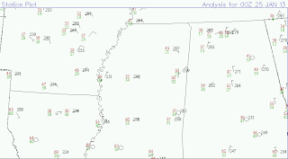
This evening, temperatures across the Magnolia state have quite a spread to them--low and mid 60s across the southern portion of the state while some spots in north Mississippi are in the 40s. This is thanks to a frontal boundary that has stalled across the central portion of the state. Indications are that it will try to inch back north as a warm front overnight into tomorrow morning and this may bring a few passing showers across central and northeast Mississippi. This front will get one final "kick" from the upper levels to help push it down towards the Gulf Coast before it will stall again thanks to the upper flow transitioning into a more zonal flow pattern.
Behind this system, high pressure will settle in from the north and keep us dry at least for the remainder of the weekend into the first part of Monday. Models show this high pressure center sliding off to our east during the day Sunday setting up a southerly flow across the Lower Mississippi River Valley. This will help gradually increase moisture across the region, as well as warm the temperatures up into the middle 60s.
The map above is taken from today's run of the 18z GFS model valid for Midnight Sunday evening. The colors represent temperatures at 850mb with the winds overlaid as well. Given a southwesterly wind direction and warmer temperatures located to our west (relative to our north), we can assume some subtle warm air advection is occurring.
This map represents vorticity at 500mb Sunday evening. This map jives up well with the previous one in that we can expect synoptic uplift across portions of the Lower Mississippi River Valley during the evening hours of Sunday. With increasing moisture thanks to the southerly flow aloft, it appears some rain showers may break out as this warm front continues to lift toward the north. It won't rain everywhere, but be aware of a few passing showers Sunday evening into Monday morning.
Monday and Tuesday look to be "primer" days; that is, increasing southerly flow helping to bring additional moisture in advance of an approaching cold front that looks to sweep through the Deep South Tuesday night into Wednesday morning. This will help push temperatures near the 70 degree mark along with mid to high level clouds as well, but no rain showers are expected during this timeframe.
Parented by a strong upper-air trough, this cold front looks to have sufficient instability and wind shear to provide the potential for strong to severe storms. Of particular note is the broadly diffluent flow over the LMRV overnight Tuesday; that is, the spreading out of the wind vectors over a specified area. Additionally, notice the green across Mississippi; this represents slower winds relative to those immediately southwest of that region. This seems to indicate speed divergence as well; both of these entities help to enhance rising air/lift at the surface.
(source: www.spc.noaa.gov)
The above image is the SPC Day 4-8 severe weather outlook. The green area represents a relatively high confidence of severe weather; specifically, it represents at least a 30% or greater probability of severe weather within 25 miles of any given point within that green circle.
Please be weather aware Tuesday into Wednesday of next week as it appears parts if not all of Mississippi could be dealing with a threat for severe weather. It is too early yet to be specific on exact timing and the specific threats, so please check back for further information throughout the weekend!
Have a wonderful Friday, and God Bless!
IW


No comments:
Post a Comment