As can be the case across the Southeastern states, we are facing another threat for severe weather during the Tuesday - Wednesday timeframe. I'll iron out the details/specifics of the system below.
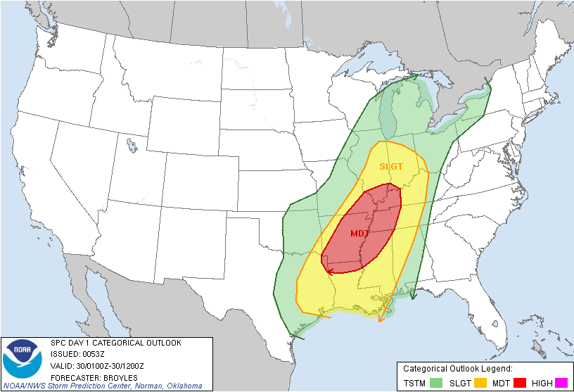
In the images above, the Storm Prediction Center (SPC) has upgraded their day 2 outlook to a categorical moderate risk for the Arklamiss area, with a large slight risk surrounding that extends from Lake Charles north to near Indianapolis. Within the moderate risk, there is a 45% chance of severe weather within 25 miles of a given point in the pink circle on the second map, which is a very significant probability. The hatching actually represents a 10% or greater probability of significant severe weather occurring within 25 miles of a point; that is, wind damage greater than 65kts and tornadoes of EF-2+ intensity.

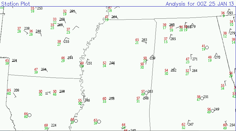
The image above is a regional view at METAR observations from 23z on 1/28, or 6 PM Monday evening. The surface winds are already out of the south-southeast and have been for much of the day. This has actually helped to advect moisture into the region all day today, with most spots already seeing upper 50s for dewpoints. This moisture content will continue to increase as the storm system to our west deepens and moves our way.
This map represents projected surface dewpoint temperatures from the 18z run of the NAM today. Notice all of Mississippi has 60 degree dewpoints with even 65+ degree dewpoints creeping up to the I-20 corridor by tomorrow late afternoon This moisture is just one of the ingredients that will be in place to support the threat for severe thunderstorms across central and north Mississippi tomorrow evening.
Again taken from the 18z NAM, this is a forecast projection of the jet stream level winds tomorrow evening at Midnight. Notice the relative maximum (160kts) over eastern Texas nosing into the Arklamiss; this is a jet streak that will help to enhance lift at the surface downstream of it across southeast Arkansas/northeast Louisiana into north-central Mississippi. It should be noted as well that that area also represents the area where the polar jet is actually phasing with the subtropical jet.
This map is a representation of the vertical velocities valid at Midnight tomorrow night. This also shows the answer to the Q-G Omega equation. Notice the widespread colors of yellow across the Arklamiss area. This jives up well with the previous map of the jet stream that shows an area of enhanced uplift.

The above image is a MODELED skew-t for a point in north-central Mississippi valid tomorrow night at Midnight. Notice the wind barbs to the right: above 850mb, the winds are pretty much from the same direction--southwest. But notice the significant increase in wind speeds; that is called speed shear and generally suggests a linear mode of severe thunderstorms. Because the winds are particularly strong with this system, winds could gust up to 80 mph along the squall line of thunderstorms as it sweeps through the area. Also of note: the winds do have some component of veering in the lowest 1km of the atmosphere. This will provide enough shear to promote a tornado threat as well, either with any cells within the squall line, or with any cell that may develop ahead of the main squall line. It should also be noted that if any storms manage to develop ahead of the line, they will pose an enhanced risk for strong to significant tornadoes.
Also, the dotted red line plotted on the map represents the temperature of the air parcel, while the solid red line represents the environmental temperature. When the temperature of the parcel is warmer than the environmental temperature, the airmass is considered unstable. This particularly profile is regarded as a "tall CAPE" profile, which generally suggests low topped thunderstorms, albeit they will still be severe.
BOTTOM LINE:
Best indications from model data right now are that thunderstorms will begin developing across eastern Oklahoma during the early afternoon hours ahead of an advancing cold front. More thunderstorms will eventually develop into northeast/eastern Texas tomorrow afternoon as well. As the airmass destabilizes and better upper support noses in, thunderstorms will quickly grow severe and likely coalesce into a squall line that will march steadily eastward through the evening and overnight hours.
Timing: Midnight - 6 AM for the GTR locally, but severe weather could begin impacting west Mississippi as early as 8 PM.
Threats: Damaging wind gusts of 60-80 mph. This could wind up being a widespread damaging wind event capable of producing significant damage over a a large area. In addition, tornadoes are possible anywhere along the squall line, AND with any cell that may can develop ahead of the line. Any supercellular tornadoes could be strong, although an isolated strong tornado is possible with any cell embedded within the main squall line.
Have a way of receiving weather information tomorrow evening into the overnight hours like a NOAA Weather Radio, as watches and warnings will likely be required.
Stay safe out there, and God Bless!
IW