Sunday, February 17, 2013

A Progressive Weather Week

We enjoyed a very nice weather day today across Mississippi with a crisp, blue sky prevailing allowing for maximum sunshine. Several locations, especially in north Mississippi, visited the mid and low 20s for low temperatures this morning but the sunshine helped temperatures rise almost 30 degrees today.

We have a quick-hitting system that will bring a cold front into our area late tomorrow afternoon into tomorrow night. Clouds will increase quickly ahead of this system, but rain showers will hold off until the nighttime hours thanks to the very dry airmass that's in place now that has to have time to moisten. The above image shows 850mb temperatures (the colors) along with the wind direction. Notice not much change in the temperature gradient across MS; this indicates minimal warm air advection and this will help mitigate severe weather chances. A line of showers and embedded storms are possible though, from about 9 PM - 3 AM here locally in the GTR.

Clouds will clear out early Tuesday morning and should make for a nice day with temperatures getting to near 50 degrees with sunshine. The above image is surface dewpoint temperatures Wednesday morning, with the white color signifying dew point temperatures at or below 30 degrees F. I wanted to show this image not only because of the dry air in place, but the wind direction as well--northerly to northeasterly. This will be crucial for our system that is poised to impact the southeast Thursday into Friday.

This map shows a potent 500mb shortwave moving through the central part of the country with southwesterly flow aloft over our area. However, this system is already taking a negative tilt and closing off aloft.

Here's the dewpoint chart for 6 PM Thursday evening. Notice the circulation over southeastern Kansas--that's the surface low pressure center which is almost vertically aligned with the upper level low. This suggests that the overall cyclone will be weakening with time. Also, the surface low appears to be occluding which will further lead to its continued weakening.


However, one cannot disregard the amount of shear with this system as well as the moisture recovery that is possible. By Thursday afternoon, at least across the southern half of Mississippi, moisture could recover sufficiently to promote a severe weather threat. And for that reason, the Storm Prediction Center has outlooked parts of central and south Mississippi into adjacent parts of eastern Louisiana for the potential for severe thunderstorms. The amount of moisture recovery and resultant instability again is critical in this severe weather forecast as the moisture just may not be able to align with the best dynamics; recall the dry air forecast to be entrenched as late as Wednesday morning into early afternoon.

Bottom line: If you live anywhere in the purple shaded areas on the map above, stay close to a reliable source of weather information during the day Thursday as severe weather could threaten your area.

Have a great Sunday evening, and God Bless!

IW

Friday, February 8, 2013

Severe Wx/Heavy Rain Setup

Good Friday afternoon! It's pretty cool across the GTR early this afternoon, and that cool feeling is being reinforced by the gusty winds across the area.

We had a weak frontal boundary pass through the area during the overnight hours into the morning that brought a few sprinkles here and there, and right along the boundary there is a relatively enhanced pressure gradient which is allowing the winds to be gusty at times this afternoon. This should relax throughout the remainder of the afternoon and tonight.

Much of the day tomorrow should be mostly clear with clouds increasing once again late tomorrow evening especially across the west in advance of the next storm system poised to impact Mississippi during the day and night Sunday, and potentially days after as well.

Here's the SPC Day 3 Outlook that is valid from 6 AM Sunday thru 6 AM Monday. Within the yellow areas, there could be some severe weather issues to deal with, particularly Sunday afternoon and evening. Let's talk about why..

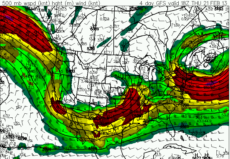
Here's the 500mb GFS forecast for Sunday evening at 6 PM. We see a strong shortwave trough that is ejecting northeast into the Upper Midwest, with a ribbon of strong winds associated with it from across much of the middle and lower Mississippi river valley. Also to note, however, is the broadly positively tilted long-wave trough that's situated across much of the central and western CONUS (contiguous US).

At that same time, a cold front will be approaching from the west. Showers and storms should expand in coverage and intensity Sunday afternoon to our west and gradually spread into Mississippi later in the evening hours of Sunday. There looks to be some instability with this system as well as decent wind shear, so a few severe storms are possible, primarily in the yellow areas defined above in the SPC outlook. However, these areas can and likely will change over the next two days as additional details are ironed out, so stay tuned to for further changes with this forecast.

As referenced earlier, the broadly positively tilted trough will actually remain in place and allow for several more waves of energy to ride along the aforementioned front that will likely stall somewhere across the Southeast. This spells prolonged chances of rain and potentially heavy rain that could cause some flash flooding issues in some areas by mid-week, especially in the MS Delta. The GFS model shows a more focused shortwave moving through Wednesday that could provide one last round of showers and storms before a temporary clearing occurs before the next what looks to be whopper system barrels in from the northwest by the weekend that could bring some cold temperatures; so stay tuned!

Have a great Friday afternoon, and God Bless!
IW

Friday, February 1, 2013

A Chilly Friday; A Warmer Weekend


As expected, most of the damage across the Mississippi/Arklamiss area came from damaging winds, although a few tornadoes occurred over the MS Delta into northeastern Louisiana, where an EF 2 tornado occurred in East Carroll Parish.


Here's a look at projected surface temperatures at 6 AM tomorrow from the 18z NAM. Notice a strong high pressure system building in from the north, bringing some much colder air into the LMV. Now this air will pale in comparison to the air up north, where temperatures tonight will be -15 to -25 below zero near the Canadian border--BRR! The front bringing these cooler temperatures may kick off a few flurries over far northeast MS late tonight, but no measurable snow is expected.


A vort max will move just to the north of the area and both the GFS/NAM are picking up on the chance of at least a few showers during the afternoon hours of Saturday. Given the relatively dry air that will be in place, no widespread heavy rains are expected.


Our next major storm system looks to affect the LMV sometime next weekend. Early forecast instability parameters from the GFS indicate that thunderstorms could be involved, but it is much too early to speculate on the severity of these storms. The take-away message is that another bout of showers and thunderstorms appears on the table sometime next weekend, particularly next Sunday. We'll iron out the details as we head throughout next week.

Enjoy your Friday, and God Bless!!

IW

P.S. The maps used were gathered from yesterday, 1/31/13